Erwin, Tennessee sits at the edge of the Cherokee National Forest with the Nolichucky River Gorge on one side and the Unaka Mountains on the other. That geography means waterfalls are everywhere — some easy enough for kids, some serious enough to earn them. Most people who visit the area don't know half of what's out here.
We're at Mountaineer Storage on Highway 107 in Chuckey — right between Jonesborough and Erwin on the same corridor that connects you to most of these trailheads. This guide covers seven waterfalls within about 30 minutes of Erwin — with honest notes on difficulty, what to expect, and what to watch out for.
Check trail conditions before you go, especially after rain. Several of these involve creek crossings that can become impassable when water is high.
Quick Reference — All 7 Waterfalls
Rock Creek Falls
Rock Creek Recreation Area · 6 miles from Erwin · TN-395 East
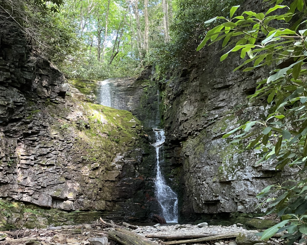
Rock Creek Falls is the most popular waterfall hike near Erwin and for good reason — it's spectacular. The trailhead is inside Rock Creek Recreation Area, a Cherokee National Forest campground built by the Civilian Conservation Corps in the 1930s at an elevation of 2,300 feet. On a hot summer day it's noticeably cooler up here than in the valley.
The trail follows Rock Creek upstream into the Unaka Mountain Wilderness with four creek crossings — the last section climbs steeply before you reach the lower falls. Keep an eye out for the short side trail to the lower falls before you make the final push to the top. The upper falls are two-tiered and about 50 feet — worth every step of the climb.
The Appalachian Trail is just 3.1 miles east at Indian Grave Gap, and Beauty Spot is accessible from nearby Forest Service Road 230 — making this area one of the best day trip destinations in all of East Tennessee.
Getting there: From I-26 take exit 34 to Main Street (TN-107) in Erwin. Take TN-395 east for 3.5 miles to Rock Creek Recreation Area. Bear safety rules apply — food storage strictly enforced.
Sill Branch Falls
Clark's Creek Area · Cherokee National Forest · Near Erwin
Sill Branch Falls is the easiest waterfall hike in the area — just one mile round trip through a shaded mountain cove in the Clark's Creek section of Cherokee National Forest. The trail follows a clear stream through hemlock and rhododendron before reaching a 20-foot cascade over a rugged rock ledge into a shallow pool. Short enough to do with kids, beautiful enough to come back to in every season.
It's one of the most popular trails in the area — you'll likely see other hikers. Go mid-week or early morning on weekends to have it to yourself. After rain or snowmelt the falls run wide open. In drought it can reduce to a trickle.
Getting there: Follow Clark's Creek Road until it turns to gravel, continue 1.5 miles, pass the first parking area on the left — trailhead and parking are ahead on the left. The parking area is opposite the trailhead — look for the blue triangle blazes at the signpost.
Squibb Creek Falls
Horse Creek Recreation Area · Off TN-107 · Sampson Mountain Wilderness
This is the one that earns it. Squibb Creek Falls sits at the end of a 4.1-mile out-and-back trail deep in the Sampson Mountain Wilderness — one of the most remote sections of Cherokee National Forest accessible from Highway 107. The Sampson Mountain Wilderness has the second highest bear population of any wilderness area in the Eastern United States after the Great Smoky Mountains. You are very likely to see bear sign. You may see bears.
The trail involves 12 or more creek crossings — your feet will get wet, full stop. Wear appropriate footwear. The trail is not blazed inside the wilderness boundary, so pay attention to the route. From the parking lot, follow Forest Road 94 for 0.2 miles, cross the wooden bridge left into the wilderness, continue to the Squibb Creek crossing — take a sharp right over Squibb Creek before the Turkey Pen Cove Trail sign. From there it's 12 crossings upstream to the falls.
The payoff is a 25-foot waterfall pinched between boulders before fanning out over a large rock at the base. The height is deceptive — the way it twists makes it look taller than it measures. Come in spring or fall when water is running hard for the best experience.
Worth knowing: Reviewers have flagged yellow jacket nests near creek crossings in late summer — use caution. Trail is not blazed. Bring a map. This is genuine backcountry.
Getting there: From Greeneville take TN-107 north for 6 miles, follow signs to Horse Creek Recreation Area.
Pete's Branch Falls
Horse Creek Recreation Area · Off TN-107 · Best in wet season
Pete's Branch Falls is the easier alternative to Squibb Creek if you're visiting Horse Creek Recreation Area — shorter trail, shorter distance, but a taller waterfall at 45 feet. The trail starts left of the Poplar Cove trailhead after the first creek crossing and follows the creek through five crossings to the falls.
Come in spring or fall for the best flow — in dry months it can reduce to a trickle. This one pairs perfectly with Squibb Creek if you want to do both in a day and have the fitness for it.
Getting there: Same parking area as Squibb Creek Falls at Horse Creek Recreation Area. From Greeneville take TN-107 north 6 miles and follow signs to Horse Creek.
Margarette Falls
Dry Fork Creek · Near Greeneville · Cherokee National Forest
Margarette Falls is one of the most photographed waterfalls in Northeast Tennessee — a spectacular 60-foot fan-shaped drop in the Bald Mountain region near Greeneville. It's one of the few waterfalls in the area that truly impresses from a distance as much as up close. The first half mile follows an easy closed forest service road before the trail steepens toward the falls.
This trail gets crowded on weekends and in summer — arrive early or on a weekday if you want it to yourself. If you're feeling adventurous after the falls, experienced hikers can continue off-trail upstream to the lesser-known Bailey Falls.
Getting there: Located in the West Dry Fork area of Cherokee National Forest near Greeneville. From the parking lot follow the forest road 0.5 miles to the signed trail junction — take the trail right, then stay left at the fork toward Margarette Falls Trail.
Martin's Creek Falls
Martin's Creek Road · Right outside Erwin · Best after heavy rain
Martin's Creek Falls doesn't get the attention it deserves. It's not well known, it's not on most lists, and the road getting there requires a high-clearance vehicle for the last gravel section. But what you get at the end is a 20-foot waterfall just a short walk from the road — peaceful, shaded, and almost always quiet. On a weekday after rain, you may have it entirely to yourself.
In drought conditions it can reduce significantly. Come after rain for the best experience. The trail to the falls is short and established, though it dog-legs left around some fallen trees in the middle section — pay attention.
Getting there: From I-26 take the Erwin/Jonesborough exit (#37) east into town. Drive through four red lights on Love Street, continue straight on Okolona Dr, then turn left at Martin's Creek Road. Continue 1.5 miles — last 0.9 mile is gravel — to the unmarked trailhead on the left. Room for one or two cars.
Rocky Fork Falls
Rocky Fork State Park · Near Erwin · Series of falls on Lower Higgins Creek
Rocky Fork State Park is one of the most underappreciated state parks in Tennessee — nearly 10,000 acres of genuine wilderness just outside Erwin that most people have never heard of. The Rocky Fork Falls are a series of cascades on Lower Higgins Creek at the northern edge of the park, accessible on a gravel trail that passes multiple smaller falls along the way.
Beyond the falls, the park has exceptional fly fishing, mountain biking trails, and backcountry camping. If you're looking for a place to get away from people entirely, Rocky Fork is one of the best options in the whole region.
Getting there: Rocky Fork State Park is accessible from Erwin via US-19W south toward Spivey. Follow signs to Rocky Fork Road. Check Tennessee State Parks website for current trail conditions and access points.
Before You Go — Things Worth Knowing
Bear country is real. Horse Creek, Squibb Creek, and Rock Creek are all active bear habitat. Store all food in your vehicle or hard-sided containers. Never leave food unattended. Violations at national forest sites are ticketable.
After rain is best. Most of these falls are significantly more impressive after rainfall. Pete's Branch and Martin's Creek can reduce to a trickle in dry weather. Spring and fall are the prime seasons.
Wear the right shoes. If you're hiking Squibb Creek your feet will get wet — that's not a maybe. Water shoes or trail shoes you don't mind soaking are the right call. Flip flops will get you hurt on the rocky sections.
Cell service is limited. Download offline maps before you leave. The forest service roads and wilderness trails have minimal to no cell coverage. Don't rely on your phone to navigate once you're in.
Hurricane Helene impact. Some trails in this region still have significant blowdown from Helene in September 2024. Check current conditions with the Cherokee National Forest Nolichucky-Unaka Ranger District before heading out on longer trails.
Storing Your Gear Between Adventures
If you're spending time exploring the waterfalls and trails around Erwin and the Highway 107 corridor, you know how fast the gear accumulates. Kayaks, camping equipment, hiking gear, bikes, and RVs all need somewhere to live when you're not using them.
We're at Mountaineer Storage serving Erwin on Highway 107 in Chuckey — right between Jonesborough and Erwin, close to the trailheads in this guide. Drive-up 10×20 units for gear and equipment, outdoor spaces up to 42 feet for RVs and campers. Month-to-month, no deposits, no contracts.
Reserve online and get your gate code the same day. Also check out our Nolichucky River guide if you're planning water activities along the corridor.
Need Storage Near the Erwin Trailheads?
We're on Highway 107 in Chuckey — 15 minutes from Erwin, right on the road that connects you to most of these hikes. Locally owned, 24/7 access, no contracts.
Related Articles
📍 Mountaineer Storage LLC
2603 TN-107, Chuckey, TN 37641
(423) 948-7724 ·
mountaineerstoragellc.com